About Rapid Response
In recent years, many of the world’s largest food and agriculture companies have adopted ‘No Deforestation, No Peat, No Exploitation’ (NDPE) policies, committing to intervene when suppliers engage in deforestation and peatland development. Simultaneously, satellite monitoring data has become more sophisticated and affordable, making it possible for companies and governments to detect and respond to deforestation incidents faster than ever. Still, some palm oil buyers have failed to consistently monitor supplier concessions for deforestation.
In 2017, Mighty Earth – supported by MapHubs, Aidenvironment and Planet – launched our Rapid Response monitoring system to ensure palm buyers remain accountable to their commitments. Our system tracks deforestation and new peatland development across over 3,000 oil palm concessions in Indonesia and Malaysia. The total area currently monitored covers around 21 ~million~ hectares, or 208,000 square kilometers, an area more than twice the size of Portugal. In 2019, Mighty expanded the program to monitor the expansion of soy plantations and cattle farms in Latin America, specifically within the Brazilian Amazon and Cerrado biomes.
Palm Oil
The Rapid Response monitoring program utilizes state-of-the-art RAdar for Detecting Deforestation (RADD) alerts from Wageningen University and Global Land Analysis & Discovery (GLAD) tree cover loss alerts from the University of Maryland to identify recent potential incidents of deforestation and/or peatland development. Next, our team confirms alerts with the most recent high-quality images generated by Planet’s nano satellites. Finally, we conduct primary research to identify supply chain and financial links between the plantations and the world’s largest agricultural buyers. The team also considers cases brought to Mighty Earth’s attention via partners and independent research.
To date, the Rapid Response program has identified deforestation and peatland development in oil palm concessions in Papua, West Papua, Sumatra, and Kalimantan in Indonesia, as well as Sarawak in Malaysia. These cases have been linked to dozens of companies and their parent groups.
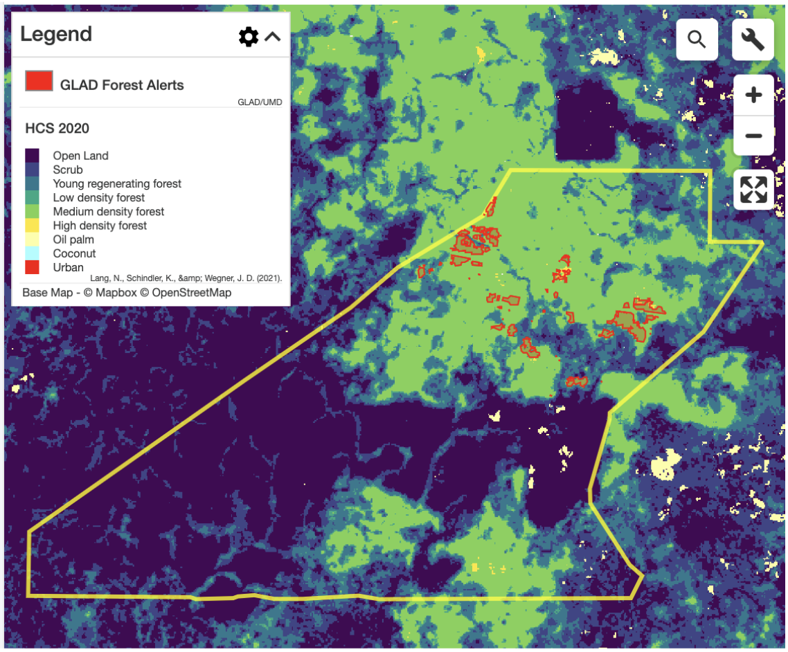
GLAD Alerts Detected within Medium Density Forest in East Kalimantan, Indonesia

When we find a case with policy violation and clear supply chain linkages, our team publishes the evidence in our monthly Rapid Response reports. We also send reports directly to implicated palm oil traders, ensuring the companies are immediately aware of policy violations and can take swift action to halt incidents before they grow into large-scale events.
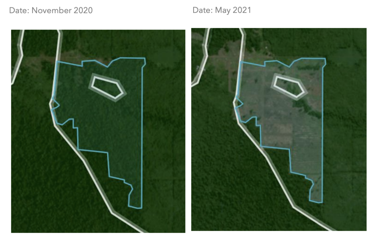
Land Clearing Detected in the PT Tandan Sawita Papua Concession in Mighty’s Rapid Response Report 34
Mighty Earth’s work has secured results most effectively with companies that have a public and transparent grievance tracking process, including a log of filed grievances and progress updates. Thus, we strongly urge all palm oil traders to invest in improving transparency for both the supply chain as well as grievance tracking. Mighty’s own Trader Tracker keeps a history of how seriously companies respond to incidents.
Visit our Palm Oil Success Stories page to learn more about the impact of our work.
Soy and Cattle
Mighty Earth also monitors large-scale cases of deforestation and native vegetation conversion in the Brazilian Amazon and Cerrado. Clearance is detected using satellite imagery, connected to the supply chains of the largest soy traders and meatpackers in Brazil, and documented in our Soy and Cattle Tracker. Because of their financial relationships with producers and influence over market access, soy traders and meatpackers play a critical role in ensuring soy and cattle supply chains are deforestation and conversion-free.
Cases are selected using satellite-based deforestation alert systems, including the Brazilian National Institute for Space Research’s DETER system as well as World Resources Institute’s GLAD (Global Land Analysis & Discovery) alerts to detect native vegetation clearance in the Brazilian Amazon and Cerrado biomes. All cases are visually confirmed using higher resolution imagery of the property to illustrate conversion of the land. The cases are selected on a regular basis, typically monthly. For each time period, the entirety of deforestation alerts are filtered to the top five municipalities with the most hectares of clearance in both the Amazon and Cerrado. From there, we select between 10-15 properties with the most clearance and the most evident supply chain links to the major soy traders and meatpackers. The intent of the analysis is to focus on the most egregious cases of deforestation with the strongest supply chain links; thus the system does not necessarily report on all clearance in the study area. Occasionally, we also include egregious cases that occur outside of these municipalities and publish special reports (such as our fires report).
PARTNERS
![]()

