JBS refusal to investigate 68 cases of Amazon and Cerrado deforestation exposed ahead of meat giant’s AGM
Link to 68 deforestation cases
As JBS shareholders gather in São Paulo for its Annual General Meeting, Mighty Earth is calling for them to challenge the Brazilian meat giant’s board of directors on its refusal to investigate 68 cases of deforestation in the Amazon and Cerrado, linked to JBS’ meat supply chain. New analysis by Mighty Earth reveals that twelve of the cases of deforestation have taken place on farms that are close to, border or overlap ten Indigenous territories.
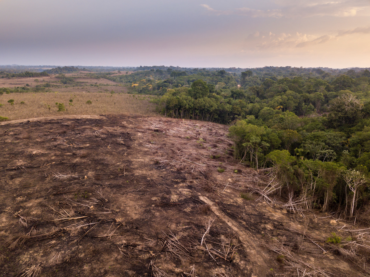
Rampant deforestation on protected land
In November and December of last year, Mighty Earth sent JBS 68 cases of deforestation covering an area more than 125,000 hectares. Nearly 60% – or some 73,600 ha – were clearance of forests and native vegetation in, nearby or bordering Indigenous legal reserves areas, that should be legally protected according to the Brazilian Forest Code.
Mighty Earth mapped the location of cattle farms in JBS’ meat supply chain and their proximity to Indigenous territories, identifying that twelve cases of deforestation are connected to the ancestral lands of ten Indigenous communities. One of the cases identified is a single cattle farm (Fazenda Santiago), located in the city of Paranatinga, Mato Grosso in the Amazon, which overlaps an area belonging to the Ikpeng Indigenous people. More than 11,000 hectares, equivalent to 16,000 football pitches, were deforested in 2022.
The new analysis is revealed as thousands of Indigenous People gather in Brasilia for the annual Acampamento Terra Livre, or ATL. The event taking place over five days is a series of peaceful protests calling for stronger rights and the demarcation and protection of Indigenous lands and territories. All the cases were analyzed, confirmed through high-resolution satellite imagery, and validated before being published. The cases analyzed between January 2019 and October 2020 were published in Rapid Response report commissioned by Mighty Earth and satellite image specialists AidEnvironment. The cases between January 2021 and September 2022 were published in the Real-time Deforestation Monitoring (RDM) produced by AidEnvironment.
The environmental groups had used the DETER daily, real-time, satellite monitoring system, developed by the Brazilian government’s space agency INPE, as the starting point to investigate and visually confirm deforestation cases with high-resolution satellite imagery. Top JBS shareholders approached by Mighty Earth ahead of the AGM include BNDES (Brazilian Development Bank), BTG Pactual, Vanguard and BlackRock.
JBS fails to investigate deforestation
In January, JBS informed Mighty Earth’s CEO Glenn Hurowitz that it would not investigate the deforestation cases as it relies solely on PRODES data, another satellite imagery-based deforestation monitoring system. PRODES was developed by INPE, a decade before DETER, and reports deforestation rates annually. INPE insists that both systems are complementary, representing powerful tools for the Brazilian government and the private sector to monitor and identify deforestation.
João Gonçalves, Senior Director (Brazil) at Mighty Earth said:
“It’s totally irresponsible for the world’s largest beef company JBS to sit for months on the 68 deforestation cases in the Amazon and Cerrado that Mighty Earth shared with the company last year.” “There is no acceptable justification for the world’s biggest meat company to refuse to act on confirmed deforestation in its supply chain detected in real time.” “We’re urging the JBS Board of Directors and powerful shareholders at the AGM in São Paulo to step in and demand that JBS properly investigate these cases and act urgently to cut known deforesters from its meat supply chain.“
What is DETER?
The Real-Time System for Detection of Deforestation, or DETER, provides daily deforestation alerts at medium spatial resolution, so that Brazilian environmental law enforcement agencies can quickly identify and inspect new forest clearing areas in the Amazon and Cerrado. As an early warning system, DETER allows a rapid response deforestation monitoring system to locate illegal deforestation starting at 3 hectares. Analysts argue that DETER alerts serve as a strong launching pad for investigating deforestation in real-time, especially when visually confirmed with high-resolution satellite imagery.
What is PRODES?
The Project for Monitoring Deforestation in the Legal Amazon by Satellite, or PRODES, generates an annual deforestation rate for the Amazon and uses highresolution satellite data to identify areas that have been cleared between September of the previous year and August of any current year. Losses are identified starting at 6.25 hectares – deforestation of smaller areas does not enter the annual rate. Analysts say PRODES offers a strong estimate of annual deforestation rates, but the infrequency of date updates is insufficient to effectively carry out real-time monitoring systems.